Enderby Quarry |
|
|
Enderby Quarry Grace Dieu Viaduct and
Craglets |
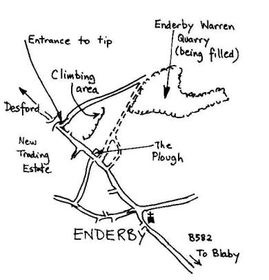
OS ref. SP534999 (Sheet 140) SITUATION and CHARACTER What
remains of this once extensive quarry is a poor reminder of its previous
scope. One hundred foot leaning walls of blank coarse granite and fine sweeps
of slab are now all buried deep under your feet. Classic
routes of the early 60's such as Euclid and Cacophany have gone. All that
remains is a broken area at the top of the old quarry. There
were several quarries at Enderby. The climbing one is properly called
Rawson's Pit or Froanes (or Frounes) Quarry. The big one to the north which
is being filled in with domestic waste (note the interesting methane
collecting system) is called Warren or Warren Hill Quarry. Enderby
Hill Ouarry (533996) and Coal Pit Lane Quarry (also called Lower Enderby
Quarry) at 542992 have both been filled in. Quarrying at Enderby, which started
in the 1870's, has gone full circle. The 8m or
so of rock exposure which remains after the main hole has been filled is
quite extensive and might give some good bouldering. The
listed climbs only occupy a small part and are heavily overgrown and need
cleaning. APPROACH
and ACCESS Enderby
is just south of the M1 /M69 junction 21. From here take the A46 east for 1
mile. Turn south on the old A46, now the B4114, for one mile, turn right
opposite the police station, pass under the M1 and after a mile you arrive at
a cross roads in the village (church on the left). Turn right along the B582.
After 500m on the brow of the hill to the right is a pub, The Plough. 250m
past this on the right was an old wooden five-bar gate which led into quarry.
All now overgrown. It is easier to walk through the entrance used by the
lorries going to the tip in Warren Quarry and walk east to the rocks. A more
discrete entrance is down the lane (it's a public footpath) by the Plough and
past the entrance to a large house. As you come into the open turn left and
get to the climbs. The
climbing is situated on a broken area of quarried hillside cutting into the
west side of Froane's Hill for a distance of some 250m. There are short steep
walls and slabs of good rock, together with more broken areas and buttresses
of shattered rock. Ownership
is uncertain. THE
CLIMBS At the
left end of the face in a bay at a lower level is a blank slab finishing at
half height. It is bounded on the right by an obvious cracked overhang. Look
carefully as all of this is behind the trees. 1 Drott 10m
VS 4c Climb the
shallow corner on the left side of the slab over overlaps to finish
rightwards onto a grassy bay. 2
Hy-Mac 8m HVS 5a The right
arete of the slab to finish up Dozer. 3
Dozer 8m VS 4c Climb the
obvious cracked overhang and slab above. 4
Scammel 8m S At a
higher level climb the left side of the slab. NOTES In the
centre of the face at its highest point and above broken blocks a route has
been made up a pillar (no description as yet). In the right-hand corner of
the main face and left of an area of steep blank rock is an obvious cracked
wall, the left side of a prominent corner. This has been climbed at 4c
(finish in the bushes). There are lots of possibilities here for good short
problems and, with gardening, some major routes. There is a nice little
bouldering slab at the far left hand end.
|