Granitethorpe Quarry Introduction |
|
|
Grace Dieu Viaduct and
Craglets Granitethorpe Quarry |
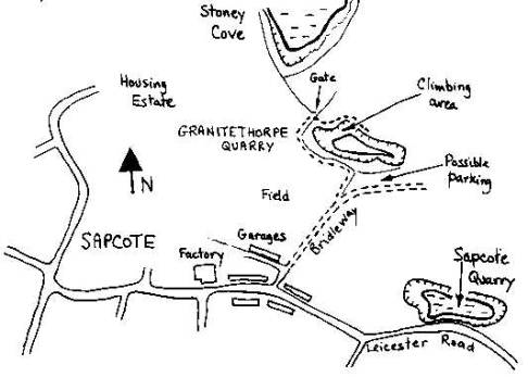
OS ref. SP495937 (Sheetl40) SITUATION
and CHARACTER Granitethorpe
Quarry was wrongly called Sapcote Quarry in the old guidebook. It has also
been called Sopewell Quarry. Granitethorpe
Quarry is a partially water-filled hole about half a mile north-east of
Sapcote village and is approached along a bridleway. The rock is diorite,
related to the rock at Mountsorrel, and the whole intrusion south of
Leicester has been heavily quarried leaving a string of pits. The quarry has
been abandoned for some time and the vegetation is taking over in some
places. However, the area at the top of the climbs is still mostly clear of
vegetation and is very pleasant on a sunny day. The climbing area faces south
and consists of a large slab together with an area of grooves further to the
east. The water
adds character to the slab but the grooves have a tree-filled ledge at the
bottom. There is very little seepage and the rock dries quickly after rain.
It is said that the water connects with Stoney Cove and that tipping at
Granitethorpe will not be permitted for fear of polluting the Cove. The
quarry was a large excavation in 1878 and contained a remarkable face of
polished rock, a photograph of which appears in "The Geology of
Leicestershire" by W.J. Harrison (1877). APPROACH
and ACCESS Sapcote
is halfway between Leicester and Hinckley alongside the M69 (access from the
north only). From Junction 2 of the M69 take the 84069 to Sapcote. From the
south take Junction 1 on to the A5. From the A5 turn left on the B4114,
passing through Sharnford. Turn left on the 84069 for Sapcote. Granitethorpe Quarry is best approached from Sapcote Village along a bridleway (signpost with a prominent horseshoe) which starts as a driveway leading round to some garages. It is sometimes possible to drive the 200m or so down the bridleway and park on the rough ground by the trees south of the quarry. Otherwise walk. Cut through into the field on the left and get to the quarry fence. Follow this round (going west). You can see the crag opposite through the wire. Keep following the fence until a gate is reached. Go under the field fence here into the quarry and follow the path round the north side of the quarry. The slab is easily found and the other routes can be seen across the bay. There have been no problems with access and the local kids fish and swim here. The best swimming access is on the south side down a steep earth bank just by the car parking spot. Ownership is unclear. There is an alternative approach going directly across the field from the housing estate.
Some of the directions are becoming slightly inaccurate due to overgrowth or better routes found. There is definitely no car access along the bridleway past the garages. This would have to be made on foot. When approaching the gate on the west side of the granite the entrance is immediately on your right after the gate. There is also another access point to the small grassy area on the south east side of the granite. if you continue down the bridle way you will reach an open area which is currently named as a possible parking area. There is an overgrown area on your left about 30 metres in front of you. There is an opening through it which leads to a small fence. Climb over this and follow a walked path virtually straight ahead until you reach the edge of the cliff. Follow the hill down to your right its quite steep, but a fairly easy climb down if you use the log on the right as you walk down. This will bring you out onto the grassy area which is a great area to swim. There is from here an easy swim to the rock face that sticks out into the middle of the quarry. there is a climb up here and we regularly use the rocks for diving off. Have fun be safe
|