Carver's Rocks Introduction |
|
|
Carver's Rocks Grace Dieu Viaduct and
Craglets |
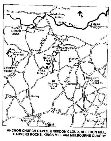
OS ref. SK332226 (Sheet 128) SITUATION and CHARACTER Carvers
Rocks are part-quarried part-natural soft Millstone grit. There are trees at
the top of the crag and parts are in jungley undergrowth. The quarried
section has an open aspect and is pleasant in the sun. The crag faces
northwest and the shaded parts can be green and slippery when wet. Because of
the poor quality of the rock and the excellence of some sandy landings either
top-roping or soloing are the most frequent modes of ascent. The area
becomes very crowded at times - particularly sunny weekends, and the trust
who manage the nature reserve are concerned about injury to other people,
either by rocks falling, imitation, or by kids getting too close to the edge.
The latter two can definitely be a problem so take special care (or avoid the
place) at peak times and watch out for kids. As with all soft sandstone, the
crag is covered with carved initials and these give names to some of the
routes. The sandstone was quarried in the 1800's for Brithy Hall and other
buildings. It gave, together with the quarry at Melbourne, the best building
stone in the area. The name is believed to be connected with Lawrence Carver
of Ticknall (b.1701 ). The rocks were called Repton Rocks in 1836 and, more
recently, have been termed Dawsons Rocks. Peter
Harding climbed here, just post-war, and must have done many of the routes. APPROACH
and ACCESS The rocks
are located four miles north-east of Ashby-de-la-Zouch at the southern end of
the new Foremark Reservoir, just off the west side of the
Swadlingcote-Ticknall road (the A514). There is a road off into a recreation
area belonging to Severn Trent and overlooking the reservoir. Park here and
walk back along the approach road to a sunken public path leading down west
to the rocks in 200m. The car park is currently (Sept. 1992) closed as a
result of pressure by the naturalists on Severn-Trent. The access route may
also change but there are public footpaths which can be used to gain access. The area
belongs to Severn-Trent and a part of it is a nature reserve. There have been
problems with climbing access in the past but, after involvement of the BMC,
these have now been resolved. CONSERVATION Carvers
Rocks are part of an SSSI. There is a serious erosion problem along the top
of the rocks caused by general traffic, wear by ropes and the washing away of
the soft rock by water flow. In order
to reduce the erosion several measures have been agreed by the BMC. More may
well follow. 1)
There
should be no abseiling. This will save the routes, the top of the crag, and
the trees that protect the soil at the top of the crag. It is the single most
important conservation measure. 2)
When top roping from the ground use long slings on
the trees so that the karabiner hangs over the edge. This prevents the rope
cutting into the trees and also sawing into the ground. It also helps keep
abrasive sand out of your rope. If permanent bolts are placed, use the bolts
and not the trees. |